CBEP is funding a new Casco Bay coastal ocean model, which will generate daily three-day forecasts of ocean conditions in Casco Bay at high spatial resolution. It will offer hourly predictions of currents, water levels, wave heights and wave periods, salinity and temperature.
Such predictions are essential for storm surge and flood prediction, port operations and emergency management. Urban ocean models can also inform environmental mitigation systems such as oil spills response and stormwater management. The model will clarify processes in the coastal ocean, including pollution transport, biogeochemistry and coastal ecology.
The Casco Bay model is being developed by Changshen Chen, of the University of Massachusetts, Dartmouth, in association with the Northeastern Regional Association of Coastal Ocean Observing Systems (NERACOOS). The model will be a nested submodel of the Northeast Coastal Ocean Forecast System (NECOFS). The Casco Bay model is expected to be in full operation by summer of 2023.
Once the model has been developed and fully validated, it will become a valuable regional tool. Our vision is to adapt and extend the model in coming years to make model outputs readily available and to address community needs and support Casco Bay science and monitoring.
Community engagement is a key part of that effort. CBEP held a series of community workshops and meetings in fall of 2022 to learn how the Casco Bay Model can help.
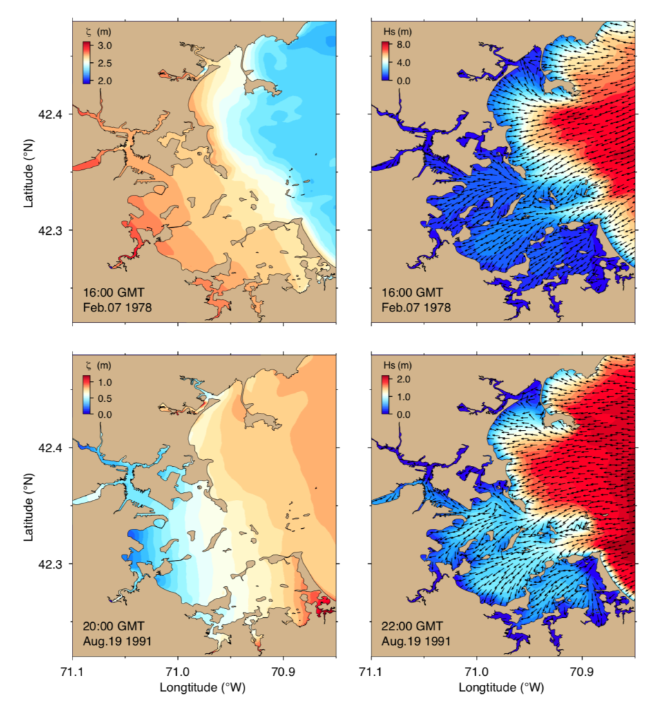
As an example of what will be possible, Chen et al. (2021) used a similar model of Boston Harbor (graphic, above) to analyze flood risk, based on two historical storms. The model suggested that a Nor’easter in 1978 led to more extensive flooding in the inner harbor, and higher waves in the outer harbor. than a 1991 hurricane. The differences related to wind direction and the timing of peak storm conditions compared to high tide. Chen and his collaborators went on to model how sea level rise would affect storm surge and waves in the future, highlighting areas where future storm risks are likely to increase.
Credit: Figure eight from Chen, C., Lin, Z., Beardsley, R.C. et al. Impacts of sea level rise on future storm-induced coastal inundations over Massachusetts coast. Nat Hazards 106, 375–399 (2021). https://doi.org/10.1007/s11069-020-04467-x.