South Bay
The South Bay webpage contains the following:
- Regional Maps
- Fore River and Back Cove
- Southern Bay
- South Bay Resources
- CBEP South Bay Fact Sheet containing highlights of the State of Casco Bay 6th edition report
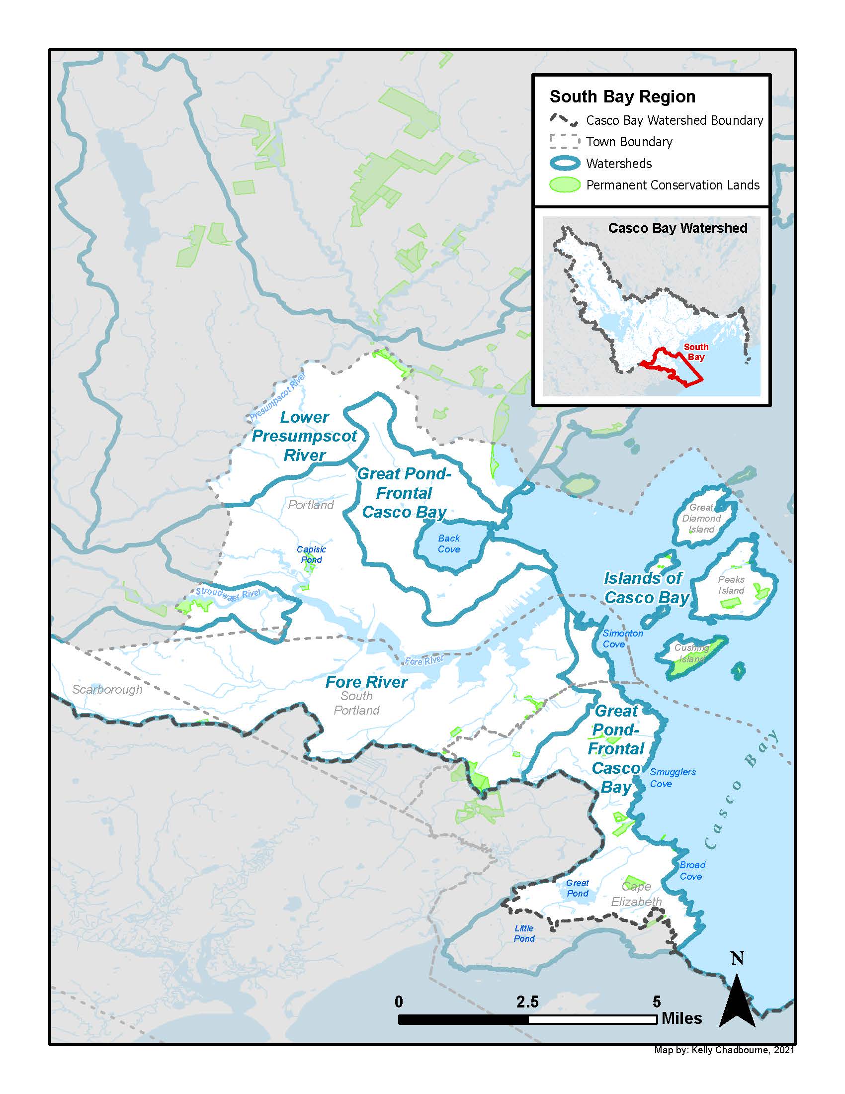
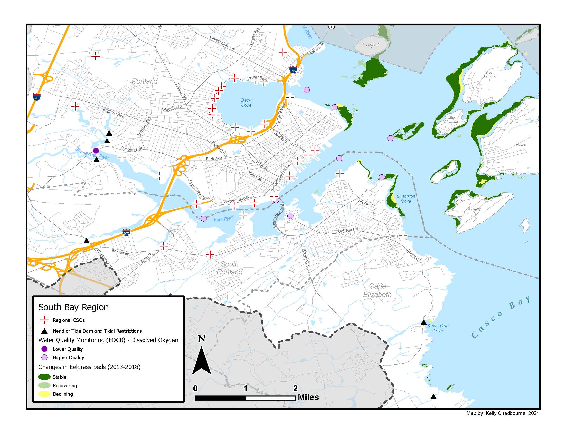
Fore River and Back Cove
The Fore River is a short, horn-shaped estuary, approximately 5.7 miles long, that forms the boundary between Portland and South Portland. The Fore River is host to Portland Harbor, and many of Casco Bay’s port facilities rim this estuary, which begins just southwest of Portland at Stroudwater Village, where several creeks converge, and where a large remnant tide mill remains next to Outer Congress Street.
Several freshwater streams empty into the Fore River including Trout Brook, Long Creek, Stroudwater River, Anthoine Creek, Barberry Creek, Red Brook, and Capisic Brook. The largest of these is the 15.2 mile long Stroudwater River, which originates at Duck Pond in Buxton before travelling through Gorham and Westbrook and ending at a head-of-tide dam in Portland. Smaller tributaries to the Stroudwater River include Deering Brook, Gully Brook, Fogg Brook, Strout Brook, and Silver Brook. (Stroudwater River Survey report, found on Town of Gorham website.)
Long Creek is a meandering stream with four primary branches. Long Creek’s headwaters originate in Westbrook, from where it flows through the Maine Mall area of South Portland. Its several branches join together and flow into Clark’s Pond, along with Red Brook. Clark’s Pond waters then flow into the Fore River, and ultimately into Casco Bay. Years of urbanization have significantly impaired Long Creek’s health, as well as its ability to support recreation and wildlife, such as brook trout and the rainbow smelt with spawn at the outlet of Clark’s Pond each spring (in declining numbers). A primary cause of the stream’s degradation is increasing volumes of stormwater runoff – and the various pollutants associated with it – flowing into its waters from impervious areas such as parking lots, roadways, and rooftops. As a result, Long Creek no longer complies with state and federal water quality standards and is classified as one of 31 “urban impaired” streams in Maine, along with most of the other streams that flow into the Fore River. State and federal law require that Long Creek be restored to meet water quality standards.
Back Cove, once a complex ecosystem of tidal marsh and tidal mudflats that extended to Deering Oaks Park, is today the site of commercial and residential developments. Fringing salt marsh rings the western shores of the Cove, and several small creeks feed into this estuary from the adjacent uplands. At low tide, extensive mudflats host shellfish, worms, and their predators including wading bird and waterfowl.
Southern Bay
Extending nearly 6 miles into the ocean, rimmed by craggy shores, rocky intertidal habitat and sandy pocket beaches, this stretch of shoreline marks the southern entrance to Casco Bay and Portland Harbor and includes the eastern coast of South Portland and Cape Elizabeth. Significant freshwater bodies include Great Pond, the largest fresh water body in Cape Elizabeth, and Alewife Brook, a small coastal stream that hosts a river herring run and empties to Casco Bay at Peabbles Cove. This shoreline includes the iconic Portland Head Light at Fort Williams, and Two Lights State Park, which is the southernmost part of Casco Bay.
South Bay Resources
Cape Elizabeth Conservation Committee
Seven-member board whose responsibilities include planning, construction and maintenance of trails, hosting Trails Day, and advising the Planning Board and the Town Council on conservation issues.
Staff Contact: Maureen O’Meara, Town Planner
(207)799-0115
maureen.omeara@capeelizabeth.org
Cape Elizabeth Land Trust
Since its inception, the Cape Elizabeth Land Trust has permanently protected over 680 acres of land for public benefit. As a community-based organization, CELT strives to maintain neighborhood trail access to protected lands and to provide new, and lasting protection of valued lands in Cape Elizabeth.
330 Ocean House Road, Cape Elizabeth ME 04107
info@capelandtrust.org
207-767-6054
https://www.capelandtrust.org/
Land Bank Commission, City of Portland
The Land Bank Commission is responsible for identifying and protecting open space resources within the City of Portland. The commission seeks to preserve a balance between development and conservation of open space important for wildlife, ecological, environmental, scenic, or outdoor recreational values.
The Land Bank Commission meets the second Thursday of the month, 5:00 – 6:30 P.M.
389 Congress Street, Room 24
(207) 808-5428
landbank@portlandmaine.gov
http://www.portlandmaine.gov/347/Land-Bank-Commission
Long Creek Watershed Management District
The mission is to develop and implement a cost-effective, environmentally-responsible, and equitable plan for restoring and protecting Long Creek and its watershed.
35 Main Street, Windham, ME 04062
(207)892-4700
http://www.restorelongcreek.org/
Portland Trails
Portland Trails is a non-profit land trust that transforms Greater Portland into a healthier community through trails, active transportation, conservation, and place-making.
305 Commercial Street, Portland, ME 04101
(207)775-2411
http://trails.org
South Portland Conservation Commission
The Conservation Commission serves as a research, advisory and advocacy group on environmental and conservation issues relating to the city. The Commission meets the first and third Monday of the month at 6:30 P.M. in the Lower Level Conference room at C.
http://www.southportland.org/our-city/board-and-committees/conservation-commission/
South Portland Land Trust
The South Portland Land Trust is a nonprofit organization dedicated to these key goals: Create and support a network of trails interlinking South Portland neighborhoods to each other and to the trails of adjoining communities; engage the community in park and trail use, open space protection, trail building and land stewardship; and encourage and support acquisition of priority open spaces.
P.O. Box 2312, South Portland, ME 04116
sopolandtrust@gmail.com
http://www.southportlandlandtrust.org/