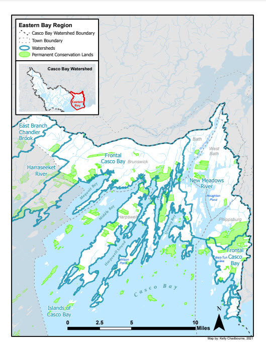
Eastern Bay
The Eastern Bay webpage contains the following:
- Regional maps
- New Meadows
- Harpswell Sound/Quahog Bay
- Maquoit & Middle Bays
- Eastern Bay Resources
- StoryMap, Resilience in the Eastern Bay, Spotlighting projects and partnerships from the last 5 years
- CBEP Eastern Bay Fact Sheet containing highlights of the State of Casco Bay 6th edition report
New Meadows
This region includes the New Meadows River and southwestern Phippsburg to Cape Small. The New Meadows River is located in the northeastern corner of Casco Bay in Maine. Its 23 square mile watershed includes parts of five towns: Phippsburg (46 % of total watershed area), West Bath (33 %), Brunswick (11 %), Harpswell (11 %), and Bath (1 %). While the total population of the five municipalities surrounding the New Meadows is close to 40,000, the number living in the watershed itself is estimated to be less than two thousand, making it a relatively undeveloped area within the more densely settled Casco Bay region. However, second home owners and seasonal visitors are not counted in this estimate.
With very little fresh water flow, the New Meadows is not technically a river, but rather an embayment – a long, narrow projection off Casco Bay. Salinity levels in the New Meadows Lake and River are close to that of the ocean. The New Meadows’ rich glacial sediment and varied topography support a wide variety of plant and animal species, and its shellfish beds are known for their high productivity.
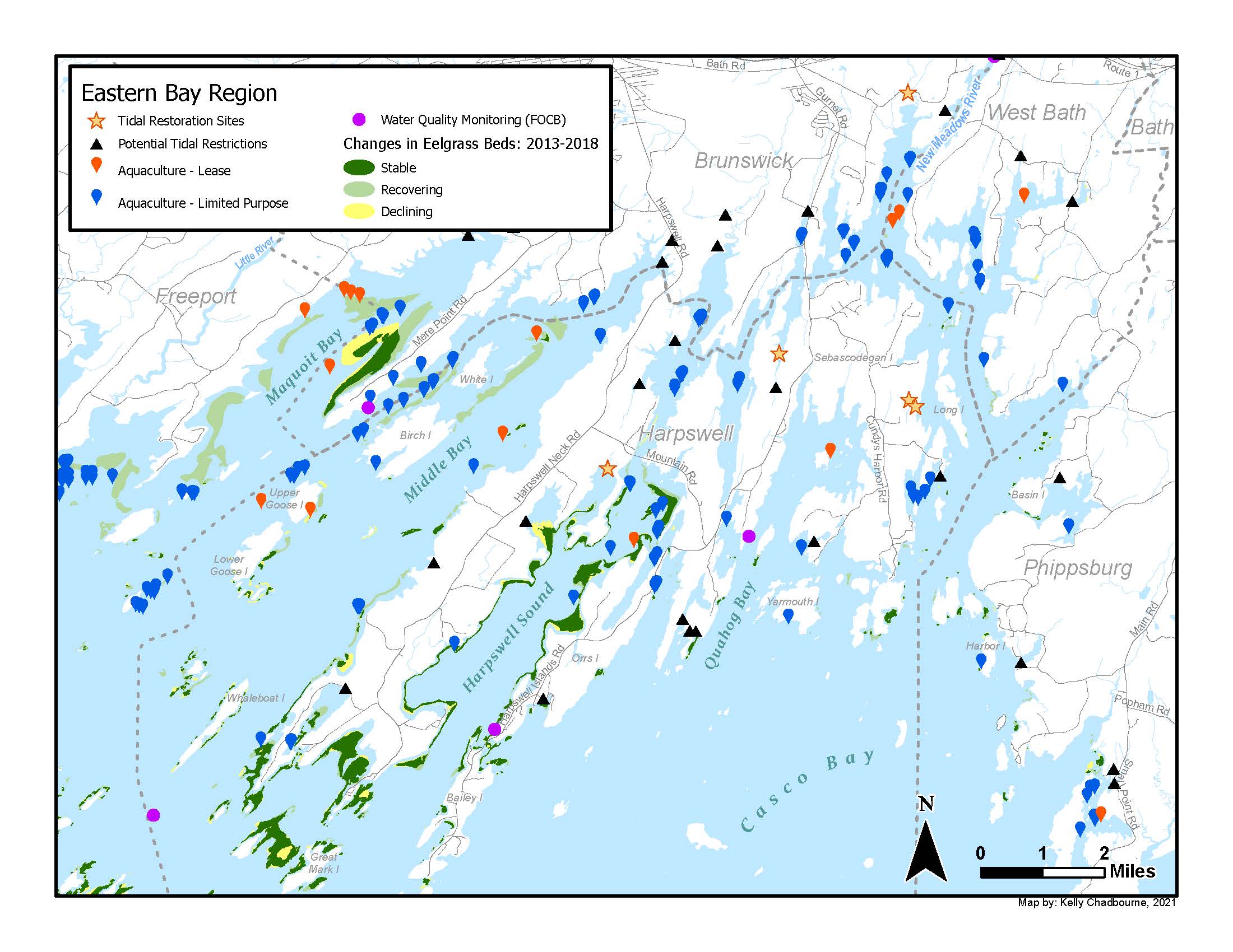
While water quality is generally good in many parts of the River, the northern areas and Lakes consistently exhibit some of the lowest dissolved oxygen levels in Casco Bay. This is exacerbated by high nutrient levels and associated algal blooms. Low dissolved oxygen episodes during warmer months can exacerbate periodic fish kills such as the infamous menhaden die-off of the early 1990s.
Much of the River and its shellfish growing areas are safe for harvesting and consumption. However, actual and potential sources of bacterial contamination often cause a substantial portion of the shoreline to be closed to shellfish harvesting.
Testing for toxic metals and chemicals in lobsters, mussels, and sediments has shown that, with only a few exceptions, levels of these contaminants in the New Meadows River are good.
Long valued for its natural beauty, recreational opportunities, and productive shellfisheries, the New Meadows is a vital resource to all those who live, work, and play in the watershed. Despite the small size of its shellfish flats, the New Meadows River produces an estimated 7.5% of Maine’s entire soft-shell clam harvest. Quahogs are also commercially harvested, and American oysters are raised at aquaculture sites in the River. The New Meadows’ productive shellfish beds support the local economy, providing jobs for more than 200 commercial diggers.
The New Meadows is a significant recreational asset in the region, offering opportunities for boating, swimming, sight-seeing, and angling. Public access to the River is provided through a boat launch and marina.
Harpswell Sound/Quahog Bay
Encompassing the watershed for numerous embayments and coves, including Harpswell Sound, Quahog Bay, Potts Harbor, Long Reach, and Ridley Cove, this region is composed of land contiguous with the rest of Cumberland County, including Harpswell Neck, as well as three large islands connected by bridges: Sebascodegan Island (locally known as Great Island), Orr’s Island, and Bailey Island and over 200 smaller islands. Harpswell has about 216 miles (348 km) of coastline and makes up one third of the shoreline in Casco Bay.
Sebascodegan Island or Great Island is an island that is a part of the town of Harpswell with the mainland portion of Harpswell to its west and Orr’s Island and Bailey Island to its south. The towns of West Bath and Phippsburg occupy the mainland to the east, across the New Meadows River. Orr’s Island forms an archipelago with Sebascodegan Island to its north and Bailey Island (reached by the Bailey Island (or Cribstone) Bridge) to its south. Orr’s Island is connected to Great Island by the Orr’s Island/Great Island Bridge.
The glacially influenced, north/south oriented landscape creates many pockets of tidal marsh and tidal mudflat that support a broad range of fish and wildlife, including shellfish.
Maquoit and Middle Bays
Encompassing three distinct embayments – the Little River, Maquoit Bay, and Middle Bay – and their watersheds, this region forms the transition from Southern to Midcoast Maine and includes parts of Freeport, Brunswick, and Harpswell. Notable landscape features include Wolfe’s Neck, Flying Point, Little Flying Point, Merepoint Neck, Bunganuc Landing, Simpson Point, and Harpswell Neck.
Collectively, this region has long been a regional and statewide focus area for conservation due to the unique combination of peninsulas, islands, tidal marsh, intertidal mudflat, and eelgrass beds that supports a range of fish and wildlife, including shellfish, waterfowl, and wading birds. Small creeks such as the Little River, and Miller Creek provide spawning habitat for rainbow smelt and other sea run fish. Eelgrass beds in this region have historically been among the most significant and extensive in the State. However, Bay-wide mapping of eelgrass beds in 2013 documented widespread loss in eelgrass cover in Maquoit and Middle Bays, which primarily seems to have taken place in 2012. While European green crabs are believed to be the primary cause of this decline, and green crab populations are known to fluctuate annually, resource managers hope that eelgrass beds can recover through a combination of natural revegetation and, if necessary, transplanting.
Eastern Bay resources
Brunswick Topsham Land Trust
The Brunswick-Topsham Land Trust was founded in 1985 to conserve the remarkable diversity of the natural heritage of Brunswick, Topsham and Bowdoin.
56 Maine Street, Brunswick, Maine 04011
(207) 729-7694
http://www.btlt.org/
Harpswell Heritage Land Trust
The Harpswell Heritage Land Trust is dedicated to protecting the natural and cultural resources of Harpswell. Their mission is to preserve and protect Harpswell’s natural resources, cultural heritage and access to the outdoors through targeted conservation, responsible stewardship and education.
P.O. Box 359, Harpswell, ME 04079 (Office address: 153 Harpswell Neck Road)
(207)721-1121
info@hhltmaine.org
https://hhltmaine.org/
Kennebec Estuary Land Trust (KELT)
The Kennebec Estuary Land Trust is committed to conserving land and wildlife habitat of the Lower Kennebec and Sheepscot River estuaries. We are a community based membership organization serving the towns of Arrowsic, Bath, Bowdoinham, Dresden, West Bath, Georgetown, Westport Island and Woolwich.
PO Box 1128, Bath, ME 04530 (Office is at 92 Front Street, 2nd floor, Bath)
(207)442-8400
info@kennebecestuary.org
kennebecestuary.org
New Meadows Watershed Partnership
The New Meadows Watershed Partnership (NMWP) is a coalition of citizens, nonprofit organizations, and municipal, state, and federal officials concerned with the health of the New Meadows River. Founded in 1999, the NMWP’s mission is to protect, improve and maintain the vitality of the ecological and economic resources of the New Meadows River and its watershed.
C/o Casco Bay Estuary Partnership
(207)780-4820
cbep@maine.edu
http://www.newmeadowspartnership.org
Phippsburg Land Trust
The Phippsburg Land Trust preserves, protects and stewards special wild and natural places in Phippsburg for the benefit and education of our children, grandchildren and future generations.
PO Box 123, Phippsburg, ME 04562
(207)443-5993
https://phippsburglandtrust.org/
Quahog Bay Conservancy
The mission of the Quahog Bay Conservancy is to revitalize the ecosystem of Quahog Bay to a robust and resilient state for all communities that depend on it. Through sustainable aquaculture, ecosystem monitoring, and community education, we aim to conserve natural habitat, protect native wildlife, foster environmental stewards, and support Maine’s working waterfront.
286 Bethel Point Road
Harpswell, ME 04079
(207)522-1105
https://quahogbay.org/